
Latourell, Oregon
The once-thriving community of Latourell, Oregon, is located along Latourell Creek, less than half a mile downstream of Latourell Falls. The community was established in the late 1800s by Joseph Latourell and was a lumber town, railroad stop, and local gathering spot for Columbia Gorge travelers. Today the community is one of a few streets with small peaceful homes. Latourell is located at Columbia River Mile (RM) 130.
Early Latourell
“Latourell Falls” was the original Post Office name of the small community located near Latourell Falls, while the railway station near the Columbia River was named “Latourell”.
According to Oregon Geographic Names (McArthur and McArthur, 2003):”Rooster Rock was the name of the first post office in this vicinity. It was established in May 1876 with John Gilstrap postmaster and was named for the natural feature nearby. Joseph Latourell became postmaster in August 1876, and the name was changed to Latourell Falls in August 1887. The office was closed in September 1964. The compiler does not know if the office was moved when the name was changed.”
The U.S. Bureau of Land Management’s General Land Office (GLO) Records database (2007) shows Joseph Latourell being granted title to 160 acres of T1N R5E Sections 29 and 30, on February 1, 1875, under the 1862 Homestead Entry Original. This location plots just west of today’s community of Latourell.
The General Land Office Records also show other Latourells being granted titles in the area. Henry, Mason, and Joseph C. were all sons of Joseph Latourell and his wife Grace Marie Ough Latourell. Henry A. Latourell was granted title to 120 acres of T1N R5E Section 30, on December 19, 1885, under the 1862 Homestead Entry Original. He was also granted title to 40 acres of T1N R5E Section 31, on August 27, 1898, under the 1862 Homestead Entry Original. Mason E. Latourell was granted title to 40 acres of T1N R5E Section 32, on February 12, 1892, under the 1820 Sale-Cash Entry, and he was granted title to 160 acres of T1N R5E Section 24, on June 11, 1897, under the 1862 Homestead Entry Original. Joseph C. Latourell was granted title to 160 acres of T1N R5E Section 29, on June 28, 1895, under the 1862 Homestead Entry Original.
Various spellings of Latourell Creek have existed over the years including “Latourelle Creek”, “Latourelle Falls Creek”, and “Latourell Creek”. The official listing is “Latourell Creek”.
The U.S. Board of Geographic Names made “Latourell Falls” the official spelling in 1915. Another spelling in use was “Latourelle Falls”.
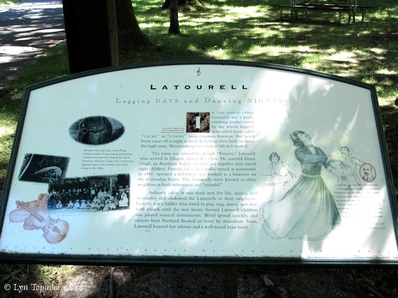
“Logging DAYS and Dancing NIGHTS” …
LATOURELL
Logging DAYS and Dancing NIGHTS
In the early 1880s Latourell was a hard-working timber town by day where logger’s spike-soled boots called “calks” or “corks” were common footwear. But heavy boots came off at night as locals kicked up their heels to dance the night away. Merrymaking was a way of life in Latourell.
The town was named for Joseph “French” Latourell who arrived in Oregon during the 1850s. He married Grace Ough, an American Indian, in 1859 and together they raised eight children. Frenchy ran a mercantile, served as postmaster in 1887, operated a fishwheel, and worked as a boatman on the Columbia River. The Latourells were known to their neighbors as both industrious and “colorful”.
Industry aside, it was their zest for life, music, and hospitality that endeared the Latourells to their neighbors. Frenchy was a fiddler who loved to play, sing, dance, and dine with friends until the wee hours. Several Latourell children also played musical instruments. Word spread quickly, and visitors from Portland flocked to town by steamboat. Soon, Latourell boasted five saloons and a well-tuned brass band.”
Source: Information sign, Latourell, Oregon, visited June 2014.
“Once a Thriving Town” …
excerpts from: Clarence E. Mershon, 2006, “The Columbia River Highway, From the Sea to the Wheat Fields of Eastern Oregon, 1913-1928”, Guardian Peaks Enterprises, p.113-115.
“… in 1856 (or ’57) [Joseph Latourell] decided to settle in Oregon. He proposed to Richard and Betsy Ough’s daughter, Grace, and filed for a homestead near Rooster Rock. On February 14, 1859, Joseph Latourell and Grace Ough married and moved into a log cabin on the homestead. Later, the log house gave way to a big farm house where they reared their eight children. …
A small town developed around the Latourell home, which was given the name Latourell to honor its founder. When the telegraph company placed its line along the old Indian trail that connected the two trading points, Celilo and the falls at Oregon City, the company employed Joseph Latourell as an operator and lineman. Soon the community of Latourell became the social center for much of the surrounding countryside. Settlers gathered at Latourell’s store and at the saloon to meet their neighbors and to hear the news from the outside world. …
Before the OR & N line came, Latourell would meet river boats at Rooster Rock to pick up the mail. When the postal service established a post office at Latourell, Joseph Latourell served as its first postmaster. He established the first mercantile store in Latourell. The younger Latourell children attended Mountain Grade School, which was reached via the old Latourell Road up a steep climb to the ridge above Crown Point. … The Latourells led the effort to construct a school at Latourell, a large two-room schoolhouse with a second story used for a dance hall. Later generations used the upstairs hall for skating, basketball games and meetings. …
In its early days, Latourell grew to be quite a thriving little town with a sizable population. There were several business establishments, including a creamery and cheese factory, a dozen or more two-story buildings and many houses on both sides of Falls Creek. The town had its own brass band for many years. …
About 1900 the Latourells moved from the ranch to a big townhouse in Latourell where they lived out their lives. They witnessed many changes along the Columbia River. The second generation of Latourells shared many of them. Sternwheelers with a shallow draft often brought visitors from Portland to picnic at Latourell (now Guy W. Talbot State Park). Joseph or Henry Latourell would meet the boats at Rooster Rock and pilot them safely through the slough. The town band greeted visitors at the dock. Inhabitants turned out to see the boats dock, sometimes two at a time. The boats would arrive about noon and leave around 4:00 p.m. The passengers picnicked in the park and danced at the dance pavilion built for that purpose. …
Upon completion of the highway [Columbia River Highway], commercial development started immediately [along the new highway, including Falls Chalet and Maffet’s Falls Villa] … Another commercial development included a garage and service station built near the west entrance to the town of Latourell. The new highway provided Latourell residents with a route to reach other communities more easily. Consequently, when Henry Shoults’ grocery store in Latourell burned in November 1916, he did not rebuild. …
Today the former vibrant community of Latourell is quiet; there are no business establishments and few residents compared to its earlier years.
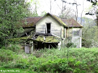
Original Farm House…

Latourell, etc
Carriage House
CCC Camp Latourell
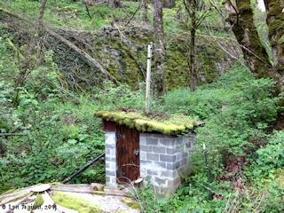
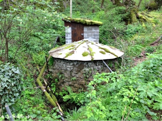
Cistern
The Dalles-Sandy Military Road
Guy W. Talbot State Park
Latourell Creek
Latourell Falls
Latourell House
1880’s School House
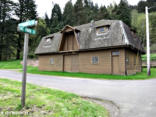
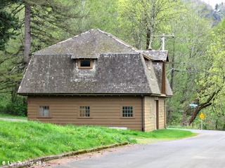

Carriage House, Latourell, Oregon. Image taken April 10, 2015.
CCC Camp Latourelle …
| Twenty-six miles upstream from Latourell, “Camp Wyeth” was established in the summer of 1933 as the CCC (“Civilian Conservation Corps”) camps began. This camp closed for the winter in October and then opened again in the spring of 1935 as “Camp Cascade Locks”. Meanwhile, another CCC camp, “Camp Latourelle” with tent-style housing was established near the community of Latourell. This camp was a “summer camp” and existed through the summers of 1934 and 1935. Camp Latourelle, F-107:“Camp Latourelle was located near Bridal Veil, OR. It was originally occupied by an advance detail from Company 697 on April 16, 1934. The remaining 200-man company arrived on April 22. Company 697 was composed of 184 Illinois recruits and 16 locally enrolled men. …One month after the camp’s establishment, Inspector M.J. Bowen reported that it was progressing satisfactorily. The camp was designed to be a summer camp and therefore was made of permanent style tents and a few rigidly constructed camp buildings. It took more time than anticipated to clear the grounds and erect the tents and buildings, partly because of rains that lasted for 24 of the first 30 days the camp was occupied. One report claims it rained for the first 36 days. Planned work projects for F-107 included clearing of tree snags resulting from forest fires, roadbuilding, and construction of telephone lines and trails. Camp Latourelle was abandoned on October 16, 1934, and was never reoccupied. … Property left at F-107 was transferred to Forest Service custody on June 24, 1937.” Source: Otis, et.al., 1986, “The Forest Service and The Civilian Conservation Corps: 1933-42, U.S. Department of Agriculture, Forest Service, FS-395, August 1986, Chapter 14, Mount Hood National Forest. |
Cistern
The Old Military Road heading down into Latourell
The Dalles-Sandy Military Road…
“The old county road which leaves the loops just below Mile Post 25, passes through a delightful area of open grass land, beside a picturesque, cliff sided point of rock, that offers a pleasing secluded retreat for ground picnics. This old road was a unit of the once Dalles-Sandy Military Road, the route of early pioneers. From here it descends to the park area and railroad station.”
Source: W.A. Langille and S.H. Boardman, 1946, State Parks Historical Sketches: Columbia Gorge State Parks, courtesy of Oregon State Archives website, 2014.
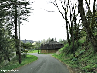
- Entering Latourell, west side, along the old The Dalles-Sandy Military Road, Latourell, Oregon. View of the old carriage house. Image taken April 10, 2015.
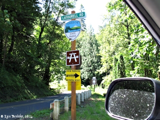
- Latourell Road junction with the Historical Columbia River Highway, Latourell Falls, Oregon. Image taken June 30, 2014.
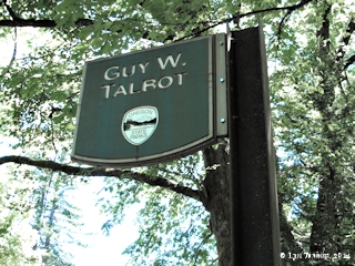
Guy W. Talbot State Park…
GUY W. TALBOT STATE PARK
“The Guy W. Talbot State Park, which Crown Point Park adjoins on the west side, is entered at Mile Post 26.18. It is described as being in Section 29, Township 1 North of Range 5 East W.M., in Multnomah County, containing 125 acres.
This park area, with its dwellings, out buildings and water system, was a gift to the State of Oregon by Guy W. Talbot and Geraldine W. Talbot, his wife, by deed dated March 9, 1929. …
The caretaker’s dwelling and other buildings are just below the highway and to the right of the approach road that leads to the picnic area and the adjoining hamlet of Latourell, which boasts a post office, small store and a railroad station. … The park is popular with Portland groups for week end outings.
The greater park acreage is on the rising ground south of the highway. These upper and lower portions, separated by the highway, are connected by a well constructed, overhead foot bridge, from which a trail ascends to the water supply source. The old county road which leaves the loops just below Mile Post 25, passes through a delightful area of open grass land, beside a picturesque, cliff sided point of rock, that offers a pleasing secluded retreat for ground picnics. This old road was a unit of the once Dalles-Sandy Military Road, the route of early pioneers. From here it descends to the park area and railroad station. …
Source: W.A. Langille and S.H. Boardman, 1946, State Parks Historical Sketches: Columbia Gorge State Parks, courtesy of Oregon State Archives website, 2014.
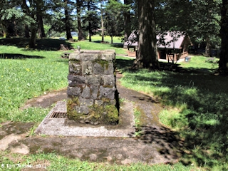

- Drinking fountain, Guy W. Talbot State Park, Lower section, Latourell, Oregon. Image taken June 30, 2014.
- Shelter, Guy W. Talbot State Park, Lower section, Latourell, Oregon. Image taken June 30, 2014.
- Sign, Guy W. Talbot State Park, Lower section, Latourell, Oregon. Image taken June 30, 2014.
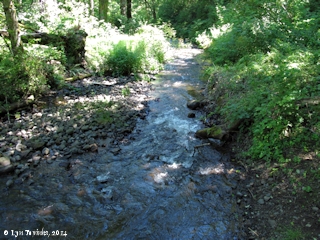
Latourell Creek …
Latourell Creek reaches the flats of Rooster Rock State Park where it merges with Youngs Creek, flowing out of the Shepperd’s Dell area. The two streams flow westward through Rooster Rock State Park to form Mirror Lake, which then merges with the Columbia River at RM 129, at the boat dock at Rooster Rock. The small community of Latourell built along the banks of Latourell Creek.
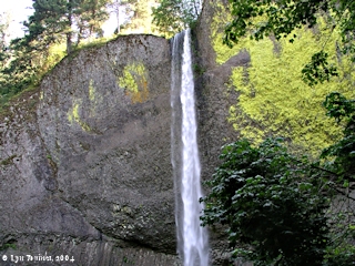
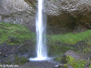
Latourell Falls…
Latourell Falls plunges 249 feet, and is one of many falls in the Columbia River Gorge located off the Historic Columbia River Highway, in Oregon’s Guy W. Talbot State Park. The falls is on Latourell Creek and is located approximately one-half mile upstream from the small community of Latourell.
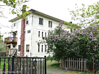
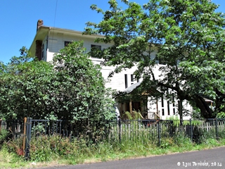
Latourell House…
According to Clarence Mershon in “The Columbia River Highway” (2006):”… About 1900 the Latourells moved from the ranch to a big town house in Latourell where they lived out their lives. …”
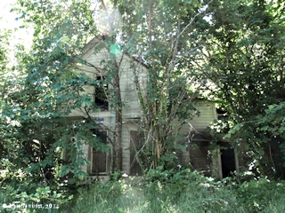
Latourell House, Latourell, Oregon. Image taken June 30, 2014.
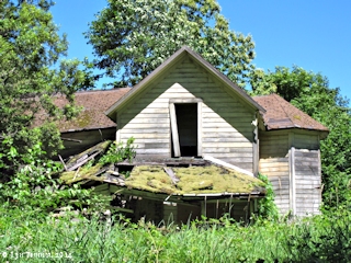
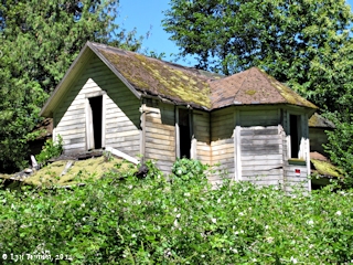
1880s Schoolhouse …
According to Clarence Mershon in “The Columbia River Highway” (2006):”… The Latourells led the effort to construct a school at Latourell, a large two-room schoolhouse with a second story used for a dance hall. Later generations used the upstairs hall for skating, basketball games and meetings. … “
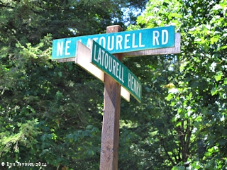
Road junction, NE Latrourell Road with Latourell Henry Road, road to 1880s Latourell Schoolhouse, Latourell, Oregon. Old schoolhouse has now been remodelled into a private residence. Image taken June 30, 2014.

Old Schoolhouse, Latourell, Oregon. Image taken April 10, 2015.
Old Schoolhouse, Latourell, Oregon. Image taken April 10, 2015.
1880’s Latourell Schoolhouse, now remodeled into private residence, Latourell, Oregon. Image taken June 30, 2014

1880s Latourell Schoolhouse, now remodeled into private residence, Latourell, Oregon. Image taken June 30, 2014.
#Awareness, #Oregon, #Latourell, Oregon, #Latourell. #UrbanExploring, #AbandonedAmerica, #GhostTown, #HistoricalFacts, #HistoricalTuesdays, #InterestingFacts, #Travel, #TravelThursdays, #UnitedStates
River Miles [RM] are approximate, in statute miles, and were determined from USGS topo maps, obtained from NOAA nautical charts, or obtained from the U.S. Army Corps of Engineers website, 2003
Sources: see Latourell Falls; and also:
- Manske, K., 2003,”A Traveler’s Guide to The Historic Columbia River Highway”: M&A Tour Books, Gresham, Oregon;
- Mershon, C.E., 2006, “The Columbia River Highway, From the Sea to the Wheat Fields of Eastern Oregon, 1913-1928”, Guardian Peaks Enterprises;
All Lewis and Clark quotations from Gary Moulton editions of the Lewis and Clark Journals, University of Nebraska Press, all attempts have been made to type the quotations exactly as in the Moulton editions, however typing errors introduced by this web author cannot be ruled out; location interpretation from variety of sources, including this website author.
